


Natural Disaster Response
A Game-Changer in Emergency Response & Disaster Recovery
A
Satellite imagery is already a proven and highly effective tool for natural disaster management and recovery. It enables quick damage assessment, identifies priority areas for aid, resource allocation and monitoring response as well as preparation for re-building.
However, just imagine having the ability to identify specific individuals and assets from satellite imagery in 'real-time' (in any spectra) in context by overlaying IoT data. This exponentially increases the potential benefits and unlocks the ability to locate, plan and deploy resources more effectively.
Saving lives, protecting assets and mitigating against financial risks.
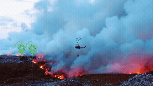

Natural disasters create chaos. By tasking satellite imagery in real-time and being able to fuse live IoT data helps identify people and rescue assets in the new disaster landscape. This helps to better control, manage, protect and deploy disaster recovery rescue, increasing their effectiveness.
Only Space Aye can identify individuals, emergency rescue and firefighting assets and vehicles in the path of developing wildfires. This better addresses the developing threat, in real-time satellite imagery. AI can classify an item but we can confidently identify exactly who and what you are looking for.
Unlock the ability to identify individuals in collapsed buildings in real-time imagery from IoT & wearable devices as well as monitor health signals and create targeted rescues plans in less time, saving more lives. Monitor people and assets in the path of flood waters and landslides in new tasked imagery to better inform decision making and mitigate against threats, reducing risks, save lives and money.
Better Disaster Recovery to Save Lives & Reduce Risk
Remote IoT sensors play a critical role in monitoring and predicting disaster events like floods (via tracking reservoir and river levels), earthquakes (seismic monitoring), wildfires (heat sensors) and more.
Pre-programmed scenarios can automatically trigger new tasked satellite imagery via Space Aye's platform to see what's happening on the ground as well as integrate terrain & AI models to better predict emerging threats from water flows or path of a wildfire. Then use IoT data to identify specific assets to either mitigate that threat or remove them from risk.
Remote Sensing & Automated Response
Whether it's disaster response, large scale public disorder or protecting the public and property in situations involving large numbers of people over larger areas, Space Aye's capability provides significant advantages.
The ability to identify, monitor and manage first responders and assets to better mitigate emerging threats or related scenarios in a real-time visual context, means better informed decisions. And, better deployment of those assets to address that 'threat' or scenario to achieve better outcomes in less time.
Emergency Service Response
How
Space Aye Capabilities can help...


Natural Disaster Relief Example: Turkey Earthquake
How
Space Aye
Capabilities
can help...
Better Disaster Recovery to Save Lives & Reduce Risk
Natural disasters create chaos. By tasking satellite imagery in real-time and being able to fuse live IoT data helps identify people and rescue assets in the new disaster landscape. This helps to better control, manage, protect and deploy disaster recovery rescue, increasing their effectiveness.
Only Space Aye can identify individuals, emergency rescue and firefighting assets and vehicles in the path of developing wildfires. This better addresses the developing threat, in real-time satellite imagery. AI can classify an item but we can confidently identify exactly who and what you are looking for.
Unlock the ability to identify individuals in collapsed buildings in real-time imagery from IoT & wearable devices as well as monitor health signals and create targeted rescues plans in less time, saving more lives. Monitor people and assets in the path of flood waters and landslides in new tasked imagery to better inform decision making and mitigate against threats, reducing risks, save lives and money.
Remote Sensing & Automated Response
Remote IoT sensors play a critical role in monitoring and predicting disaster events like floods (via tracking reservoir and river levels), earthquakes (seismic monitoring), wildfires (heat sensors) and more.
Pre-programmed scenarios can automatically trigger new tasked satellite imagery via Space Aye's platform to see what's happening on the ground as well as integrate terrain & AI models to better predict emerging threats from water flows or path of a wildfire. Then use IoT data to identify specific assets to either mitigate that threat or remove them from risk.
Emergency Service Response
Whether it's disaster response, large scale public disorder or protecting the public and property in situations involving large numbers of people over larger areas, Space Aye's capability provides significant advantages.
The ability to identify, monitor and manage first responders and assets to better mitigate emerging threats or related scenarios in a real-time visual context, means better informed decisions. And, better deployment of those assets to address that 'threat' or scenario to achieve better outcomes in less time.

In summary...
Use Space Aye's unique capability to further improve the effectiveness of satellite imagery.
Identify specific responders and rescue assets in a real-time context, make better, quicker decisions and potentially save more lives and better mitigate asset risk.
Integrate with remote sensors and automate real-time imaging and IoT integration via Space Aye's platform to better monitor & prevent loss in natural disasters.
A new level of ground truth, in real-time imagery, to save lives and reduce losses - only with Space Aye.
In summary...
Use Space Aye's unique capability to further improve the effectiveness of satellite imagery
Identify specific responders and rescue assets in a real-time context
Integrate with remote sensors to automate real-time imaging with IoT integration to monitor & prevent loss
A new level of ground truth, in real-time imagery, to save lives and reduce losses