
Real-Time Satellite Imagery, Meet IoT Data

How Space Aye's LTx merges two worlds to create uniquely powerful insights...and what that means for you.
At Space Aye, we've been working hard to bring our patented capabilities to life - by enabling the merger of located data with near real-time satellite imagery right in our Large Terrestrial Exchange (LTx) platform.
That means it's a great time to revisit the core of what the 'LTx' platform is, before we explore our new features, developments and use cases it has the potential to unlock.
Recap: The Large Terrestrial Exchange
Space Aye's LTx is a single, easy to use satellite tasking platform with access to multiple providers of satellite imagery - including Synthetic Aperture Radar (SAR) and Short-Wave Infrared (SWIR) sources, alongside high-resolution optical imagery.
By selecting an area and choosing a date range, you can simply access options across multiple satellite imagery providers, including both pre-existing archive images and future opportunities to capture new real-time satellite imagery. These can be filtered to suit your application's needs and budget, then ordered and purchased by using a simple, ecommerce-like flow from search to checking out at the 'cart'.
As well as an intuitive web-based interface, we offer API access with sample code and developer support, so that you can seamlessly integrate satellite imagery in your own on-premise workflows. Our API option allows for secure data to be kept within your own systems, whilst still accessing and using our patented capability.

What's New - Let's Meet the Data Sources
We understand that some users will be dealing with sensitive data they don't want to share outside of their organisation; yet, we've recognised that many of our customers also benefit from being able to work with non-sensitive, anonymised and even publicly-available data sources within the LTx platform.
To bring the power of our patents to those users, we've introduced data source inputs that can either be:
Remote URLs, potentially protected by authentication
Local file uploads, directly to the platform
We use a standard GeoJSON format; but we can handle the transformation of a range of other formats too. This makes it simple to upload your data, and explore our patented data fusion capability.
On top of facilitating the upload of your data into the LTx platform, we've developed new features which will make your end-to-end process seamless whilst offering more opportunities for data-rich, ground-truth results.
Ground Truth Data, Uniquely Enabled by Space Aye Technology
Scheduled Imports
With a data source configured on your LTx account, you can then easily set up a recurring schedule to regularly import data at whatever interval you choose (e.g. hourly, daily, weekly etc). You can also run on-demand imports at any time, meaning that you can request data from your own data source as and when you require it.
Alerts
Once regular/scheduled imports are set up, we have built a new tool which allows you to configure alerts based on the content of your data. These are built from conditions which are based on the properties of items in your data set, and can even be based on the location of moving sensors.
For example, an alert could be triggered:
When the temperature of more than 5 sensors are above a defined threshold
When the water level at a specific sensor is below a defined value
When failure is detected in any sensor
We've designed the system to be as flexible as possible and handle any scenarios across diverse applications.
Ultimately, alerts generate emails and notifications within the LTx platform, allowing you to act through tasking real-time satellite imagery and merging it with the data that caused the alert - which provides real-time, ground-truth data with actionable insights.
Bringing it All Together
Having satellite imagery and your data sources side-by-side in the platform, coupled with our alerts systems, opens a range of possibilities and unique insights.
Source Images for Data
Within the LTx platform, you can view a data set once imported. By starting with this data set, you can view satellite imagery in your existing library that covers the same geographical area as your data points. This allows you to see the satellite images merged with the imported data points.
You can also use the area and time range of the data set to source new imagery, either exploring past options for historical information or tasking new real-time satellite imagery to give the most up-to-date and accurate information and real-world visual context on the ground.

Source Data for Images
On the other hand, when viewing a satellite image, you can see data points that you've imported for the same area, allowing it to be overlayed and insights to be
gained.

Images from Alerts
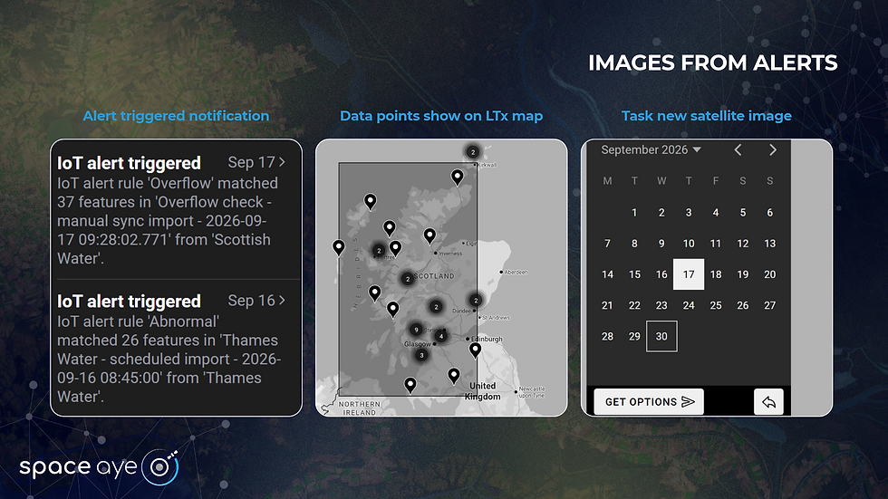
When an alert is triggered, you can click the notification which takes you straight to the data points that caused the trigger. This then lets you use the locations of those points to obtain a new satellite image in near real-time to get a real-world view of the area of the triggered sensor or data point.
Example Use Cases
Environmental Monitoring
Within Environmental Monitoring, soil moisture sensors are often used over a large area. If a collection of these sensors report values below a pre-determined threshold i.e. a low moisture level, this could trigger an alert. This would then allow you to obtain a timely SWIR image and quickly assess the wider picture in terms of soil moisture or plant water content.
Emergency Response
When time matters in emergency responses, spiking heat sensors in woodland could trigger an alert. This would then let you source real-time satellite imagery that could reveal the location and extend of the wildfires at an early stage (and identify your nearest responders by their own location data sources).
Geofencing
Automatic Identification System (AIS) data from cargo vessels could be monitored to raise an alert on entry to the vicinity of their destination, allowing the capture of visual evidence to prove location or arrival at a port. Other 3rd party data sources, like container GPS devices or other on-board communication devices can also be merged to further validate AIS data and fill in any 'visibility' gaps.
Where We're Heading...
Our near-term roadmap will close the loop from alerts to obtaining an image, with alerts triggering automated orders, subject to your imagery preferences and approval workflows.
Making geospatial imagery and data-led visual validation part of your critical workflows has never been easier, or faster. Space Aye's new LTx functionality means you will never miss the opportunity to capture imagery of critical events in your global supply chain, when you need it, anywhere in the world, 24/7.
What this space...👀
Contact the team for more information, or for an initial demo and discussion.


